G-d tells Moses the exact borders of the Promised Land
- The Lord spoke to Moses, saying: Command the children of Israel and say to them, When you arrive in the land of Canaan, this is the land which shall fall to you as an inheritance, the land of Canaan according to its borders.
South border
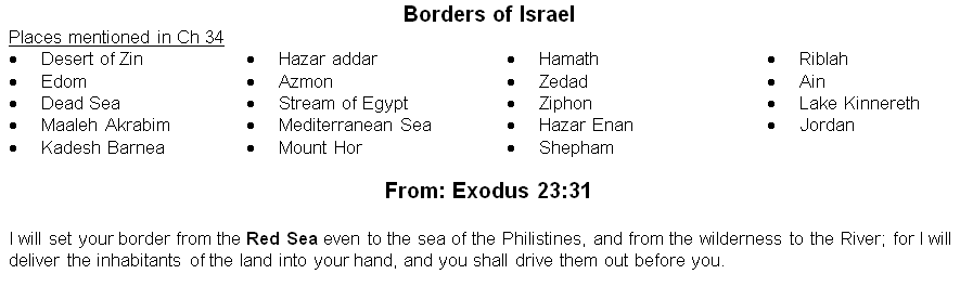
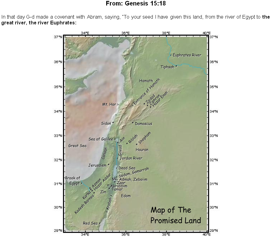
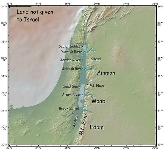
- Your southernmost corner shall be from the desert of Zin along Edom, and the southern border shall be from the edge of the Sea of Salt [the Dead Sea] to the east.
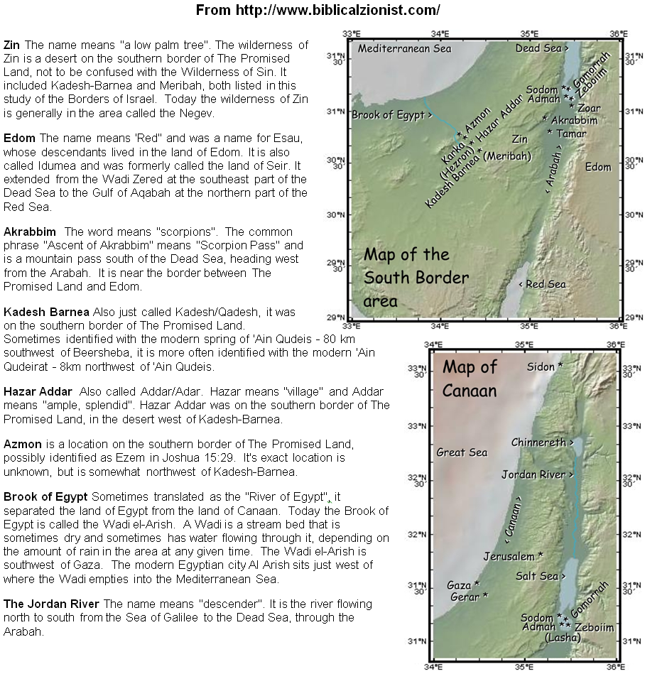
- The border then turns south of Maaleh Akrabim [elevation of Akrabim], passing toward Zin, and its ends shall be to the south of Kadesh barnea. Then it shall extend to Hazar addar and continue toward Azmon.
- The border then turns from Azmon to the stream of Egypt, and its ends shall be to the sea.
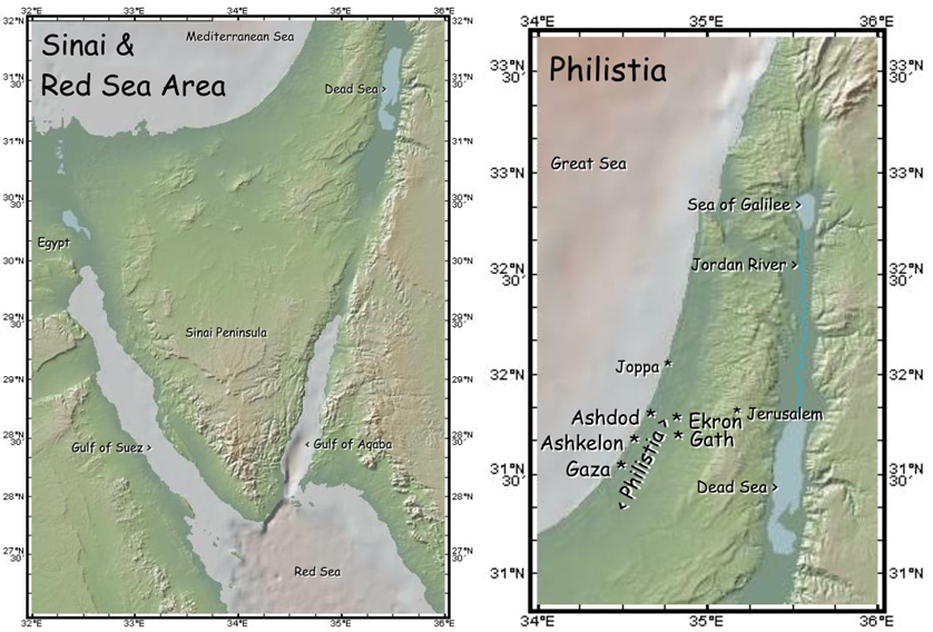
- from the desert of Zin: which adjoins Edom, beginning in the southeastern corner of the land of the nine tribes. How? Three lands lie south of the Land of Israel, each adjoining the other-part of Egypt, the entire land of Edom, and the entire land of Moab. The land of Egypt is in the southwestern corner, as it says [later] in this passage, “from Azmon to the stream of Egypt and its ends shall be to the sea” (verse 5). The stream of Egypt ran through the entire length of Egypt, as it says, “from the Shihor [river], which is along the face of Egypt” (Josh. 13:3), and it intervenes between the land of Egypt from the Land of Israel. The land of Edom adjoins it [Egypt] from the east, and the land of Moab adjoins the land of Edom at the southeastern corner [of the land of Israel]. When the Israelites departed from Egypt, had the Omnipresent wished to expedite their entry into the Land, He would have taken them northward across the Nile, and they would have thus entered the Land. But He did not do so, and this is the meaning of what is said, “God did not lead them [by] way of the land of the Philistines” (Exod. 13:17). For they [the Philistines] dwelt by the sea in the west of the land of Canaan, as it says regarding the Philistines, “those who inhabit the coastal area, the Cherethite nation” (Zeph. 2:5). He did not lead them by that route, but diverted them and took them along the southern route, to the desert. Ezekiel called it “the desert of the nations” (Ezek. 5:35) because several nations dwelt alongside it. He led them along the south, always from west to east, until they arrived at the southern end of the land of Edom. They asked the king of Edom for permission to enter his land and traverse its width in order to enter the Land [of Israel], but he refused, and they had to turn and travel along the entire south of Edom until they reached the southern end of the land of Moab, as it says, “He sent [messengers] also to the king of Moab, but he was unwilling” (Jud. 11:17). They then traversed the entire southern boundary of Moab, right to the end, and then turned northward until they had passed along its entire eastern boundary, along its width, and when they finished its eastern boundary, they came upon the land of Sihon and Og, who dwelt to the east of the land of Canaan, with the Jordan [river] intervening between them. This is the meaning of what is stated concerning Jephthah,“And they went through the desert and went around the land of Edom and the land of Moab, and they came to the east of the land of Moab” (ibid. 18). They conquered the lands of Sihon and Og, which were to the north of Moab, and came near to the Jordan, opposite the northwestern corner of the land of Moab. Hence, the land of Canaan, which was across the Jordan to the west, has its southeastern corner bordering on Edom.
- The border then turns south of Maaleh Akrabim: Whenever the term וְנָסַב (“turns”) or וְיָצָא (“extends to”) is used, it [Scripture] informs us that the border was not straight, but veered outward; the boundary line bent to the north, angling westward, so that the border passed south of Maaleh Akrabim, so that Maaleh Akrabim was within the border.
- it shall extend: The boundary stretches northward and continues angling westward, until it reaches Hazar-addar, and from there to Azmon and from there to the stream of Egypt. The term “turns” is used here, because Scripture writes,“it shall extend to Hazar-addar.” For it began to widen after passing Kadesh-barnea, and the width of that strip which protruded northward was from Kadesh-barnea to Azmon. From there onward, the boundary narrowed and turned southward, reaching the river of Egypt, and from there westward to the Great Sea, which is the western boundary of the entire Land of Israel. Thus, the river of Egypt is in the southwestern corner.
- and its ends shall be to the sea: To the western border, for the southern border no longer stretches westward past there.
West border
- The western border: it shall be for you the Great [Mediterranean] Sea and the border this shall be your western border.
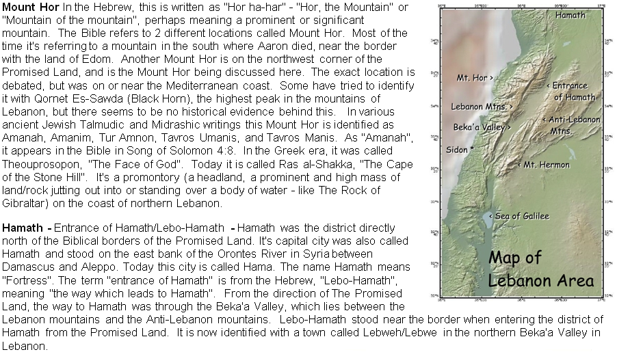
- This shall be your northern border: From the Great [Mediterranean] Sea turn yourselves toward Mount Hor.
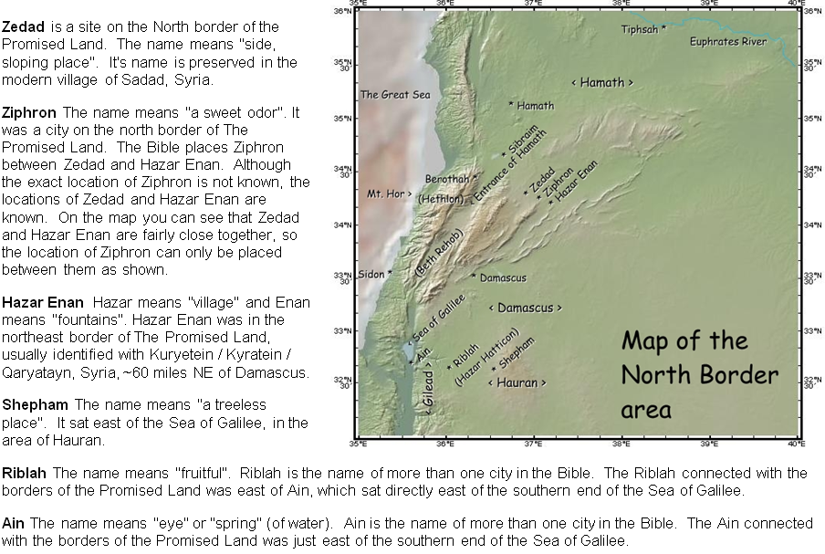
- From Mount Hor turn to the entrance of Hamath, and the ends of the border shall be toward Zedad.
- From the Great Sea turn yourselves toward Mount Hor: which is the northwestern corner. Its summit slopes down into the sea. Some of the expanse of the sea is inward of it and some outside it.
- and the ends of the border: Heb. תּוֹצְאֹת הַגּבוּל, the ends of the border. Whenever [Scripture] mentions “the ends of the border” either the boundary line ends there completely and does not continue further in that direction, or from there it spreads out, broadens, and extends backwards, continuing in a more slanting direction than [encompassed in] the original expanse. In relation to the breadth of the original dimension, it is called the ends, for that dimension ends there.
North border
- The border shall then extend to Ziphron, and its ends shall be Hazar enan; this shall be your northern border. You shall then turn yourselves toward the eastern border, from Hazar enan to Shepham. The border descends from Shepham toward Riblah, to the east of Ain. Then the border descends and hits the eastern shore of Lake Kinnereth.
- and hits the eastern shore of Lake Kinnereth: For Lake Kinnereth was within the border to the west, and the border which is east of Lake Kinnereth, descends to the Jordan. The Jordan flows from north to south diagonally, slanting eastward, moving toward the land of Canaan opposite Lake Kinnereth, and extending along the eastern flank of the Land of Israel, opposite Lake Kinnereth, until it falls into the Sea of Salt [the Dead Sea], and from there the border ends with its ends at the Sea of Salt, from which the southeastern border begins. This is how it is encompassed from all its four sides.
East border
- The border then continues down along the Jordan, and its ends is the Sea of Salt [the Dead Sea]; this shall be your Land according to its borders around.
G-d appoints chieftains of each Tribe to apportion the land inheritance
- Moses commanded the children of Israel saying, "This is the Land which you are to apportion for inheritance through lot, that the Lord has commanded to give to the nine and a half tribes. For the tribe of Reuben's descendants according to their fathers' house, and the tribe of Gad's descendants according to their fathers' house, and half the tribe of Manasseh have already received their inheritance. The two and a half tribes have received their inheritance on this side of the Jordan, near Jericho in the east, toward the sunrise."
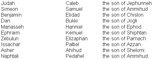
- The Lord spoke to Moses saying: These are the names of the men who shall inherit the land on your behalf: Eleazar the kohen and Joshua the son of Nun. You shall take one chieftain from each tribe to [help you to] acquire the land. These are the names of the men for each tribe, the ones whom the Lord commanded to apportion the inheritance to the children of Israel in the land of Canaan:
 |
       |
 |